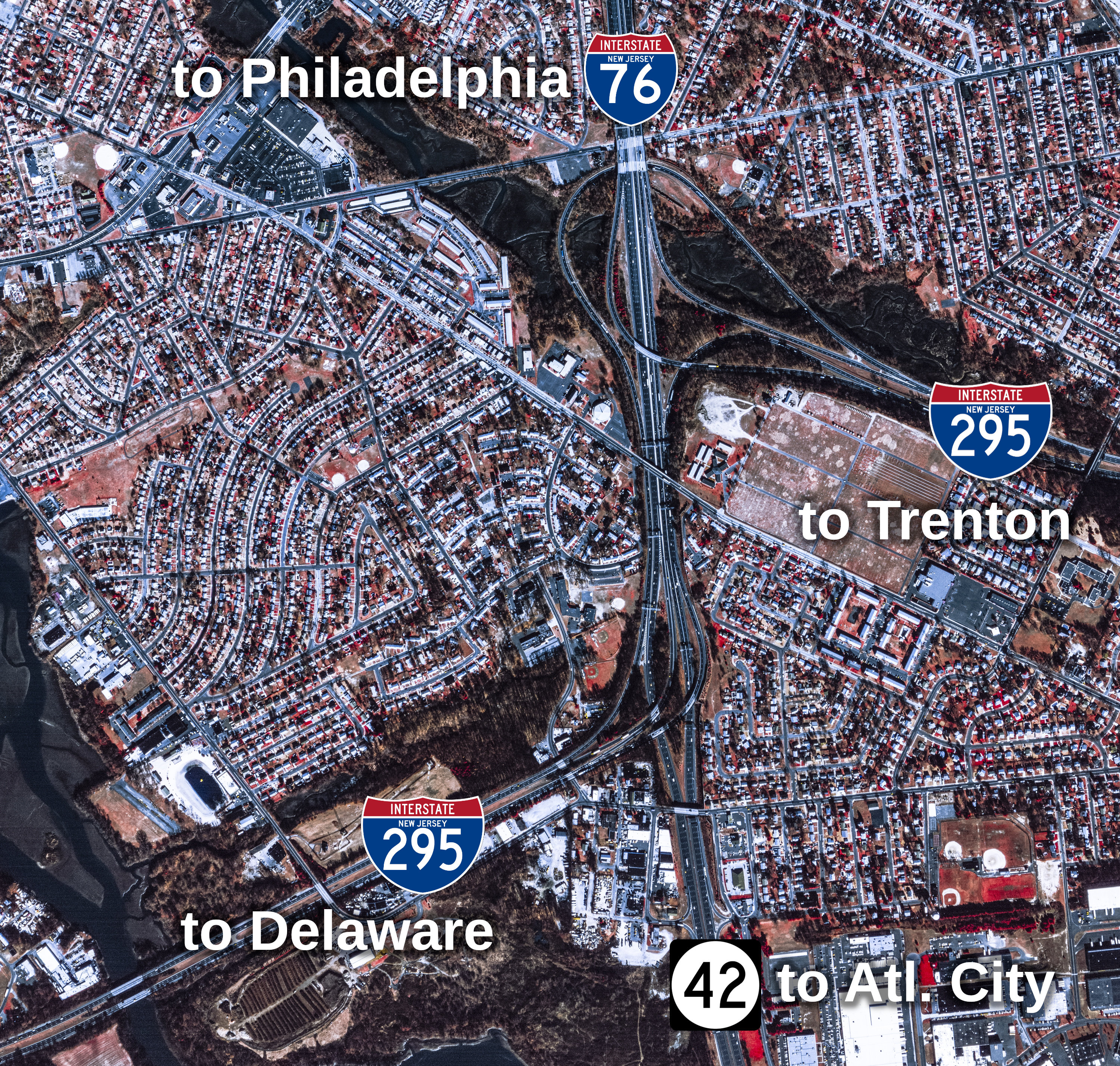
Annotated 2002 aerial image of the I-295/I-76/NJ-42 interchange. Source: US Geological Survey.
This article will discuss what I consider to be the most painful highway interchange in southern New Jersey, the connection between I-295, I-76, and NJ-42 in Bellmawr, just a few miles south of Center City Philadelphia and Camden. At this interchange, I-76 and NJ-42 terminate at one another, allowing I-76 to end at another Interstate highway, while NJ-42 continues the freeway to the Atlantic City Expressway, for traffic heading to the Jersey Shore.
This interchange, planned in the early 1950s and constructed in the late 1950s, is extremely awkward for through traffic on I-295 to navigate. In essence, it is two directional "Y" interchanges, where I-295 needs to effectively merge into and multiplex with I-76/NJ-42, and then turn away to follow its own alignment again.
I have created a short video to show the driving experience through this interchange, from the perspective of through traffic on both directions of I-295, in July 2025. While the interchange is under major reconstruction, the original design is generally still in place.
If the embedded video doesn't work, click here for this video.
The original design of the interchange is described in the December 1960 New Jersey State Highway Department (predecessor to today’s New Jersey Department of Transportation) Monthly Report, quoting a press release dated November 22, 1960.
Note: Interstate 80S is now Interstate 76.
"Motorists who drive south from the Camden-Philadelphia area on Interstate Route 80S in Camden County will have a total of five traffic lanes available today.
[...]
The widening project was accomplished by replacing the existing center island strip with four additional concrete traffic lanes, two in each direction. The resulting north and southbound five-lane roadways are divided by a 20-inch high concrete barrier curb, and each roadway is further divided by a low concrete curb that separates through-traffic traveling the inside two lanes for Walt Whitman Bridge traffic only from local traffic on the outside three lanes.
The widening project is part of an overall $2,800,000 contract that also includes paving a previously graded three mile section of Interstate Route 295 from the interchange site in Mt. Ephraim northward to Copley Rd. in Barrington."
Thankfully, the New Jersey Department of Transportation (NJDOT) is in the midst of reconstructing this interchange, allowing a direct connection between the two sections of I-295, eliminating the short multiplex with I-76/NJ-42.
Despite the fact that the interchange is finally under reconstruction, I still would like to explore why I-295 through traffic has been subject to such an awkward movement. It's especially interesting given that I-295 is technically more of a through highway through the interchange than I-76/NJ-42, at least in terms of route numbering.
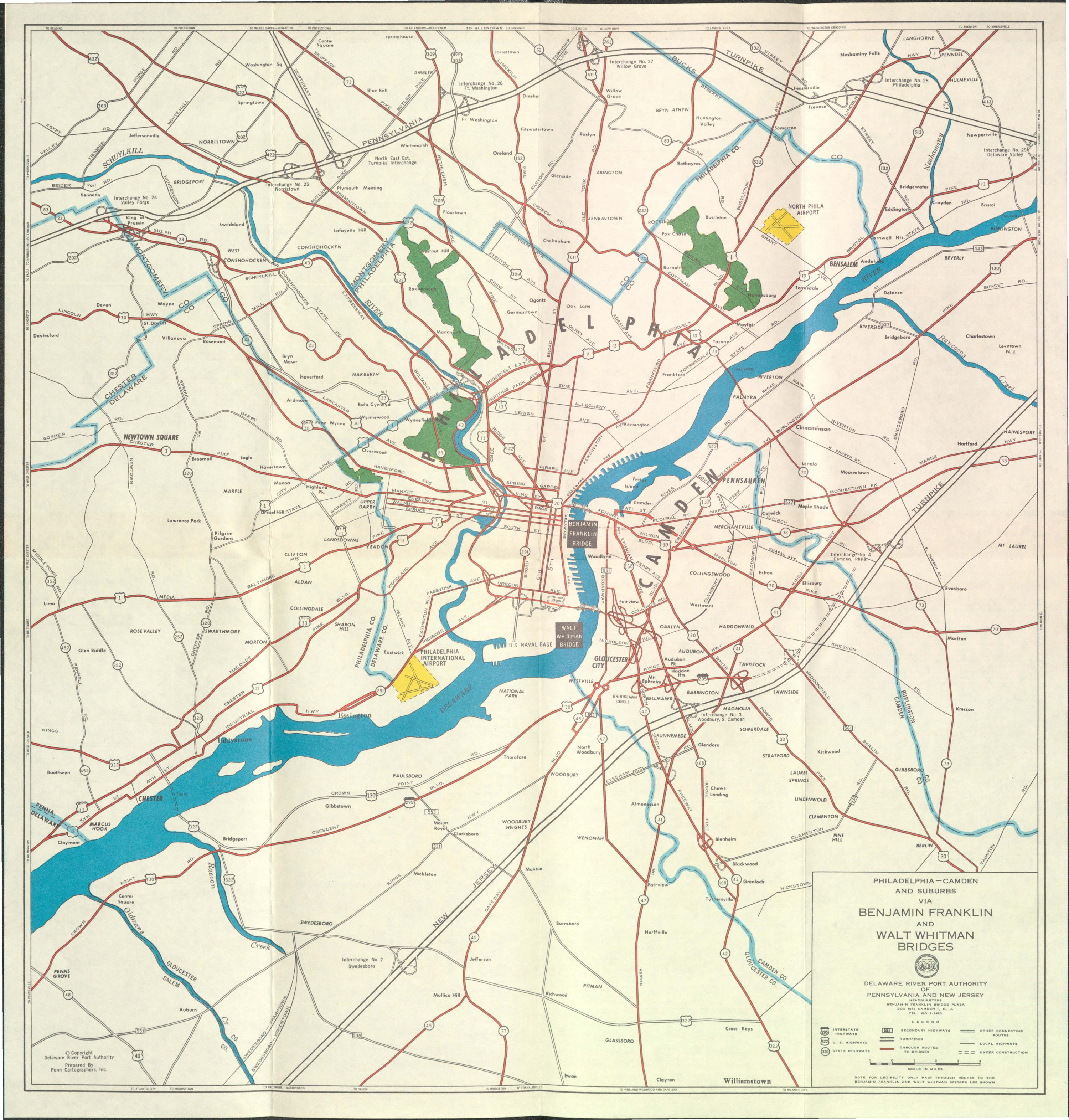
I've reviewed several documents from the New Jersey State Highway Department and the Delaware River Port Authority (owner of the nearby I-76 Walt Whitman Bridge and I-676/US-30 Ben Franklin Bridge) from 1945 to 1965 to determine what decisions could have led to this design. Ultimately, I've come up with three theories:
Internal documents from the New Jersey State Highway Department in 1953 reference the two segments of I-295 separately:
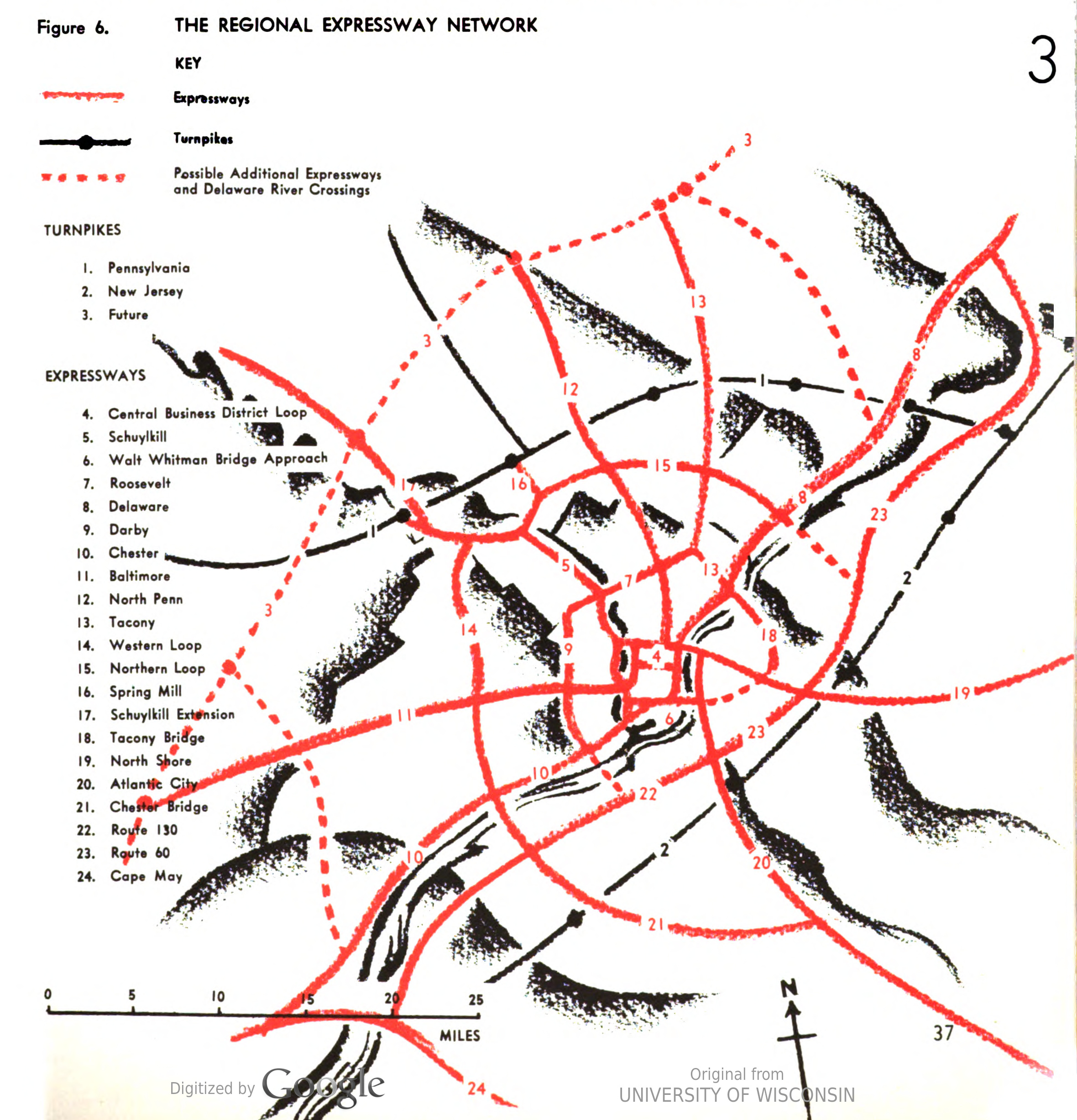
A 1955 Philadelphia City Plan also refers to these segments of today's I-295 as two separate highways, specifically the Route 130 and Route 60 freeways.
Once the Interstate Highway System was conceived, New Jersey's maps of planned Interstate highways show a "kink" in the routing of I-295 at I-76/NJ-42, showing the odd interchange was always part of the design.
Interestingly, after the creation of the Interstate Highway System, the State Highway Department only seemed to mention the highway as either I-295, FAI-108 (Federal Aid Interstate), or Route 60, regardless of location.
One exception is a 1961 Severance Study from the State Highway Department that made multiple references to the "Route 44 Freeway." I assume this was a holdover from its original construction and planning documents from those land acquisitions, as these acquisitions were done prior to the Interstate Highway System's existence.
I-295 is often described as an eastern bypass of I-95 through Philadelphia. However, with the extreme frequency of interchanges along I-295 (50 interchanges over its 67-mile original length, approximately 1.3 miles between each, on average), it seems like I-295 was really built with local access in mind.
This ultimately suggests that I-295 was truly meant as a freeway for local commuter traffic in Philadelphia's suburbs, rather than serving long-distance traffic. In other words, when I-295 was constructed, it was likely expected that very little traffic was continuing along it through the I-76/NJ-42 interchange, so the I-295 through movements were treated as more of an afterthought.
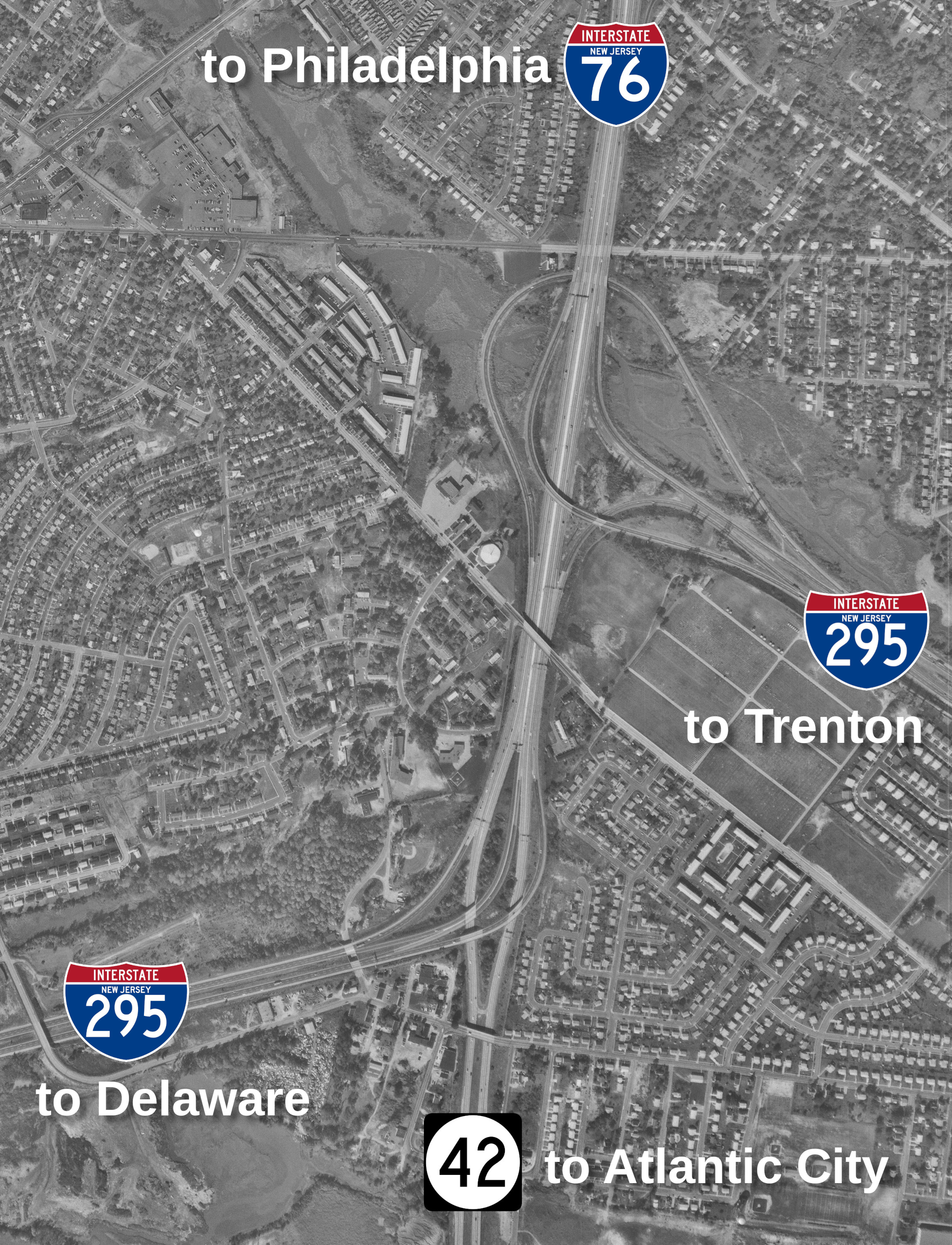
This can especially be felt when looking at the design of the ramps for the I-295 SB through route. When looking at a 1967 aerial image of the interchange (shown below), notice how the I-295 NB to I-76 WB ramp and the I-295 SB to I-76 WB ramps look very similar geometrically, as if they were designed with the same thinking, that the two theoretically separate highways were meant to take traffic to Philadelphia.
Adding to this theory, notice how the through ramp for I-295 SB seems like it’s basically "added on" to the interchange between the northern section of I-295 and I-76/NJ-42. Almost like it wasn’t part of the original design. I've searched extensively for documents suggesting that the through movements for I-295 in the northern part of the interchange were added on to the design later but can't find any evidence of that. The earliest map I can find of the interchange is in the June 1957 State Highway Department Monthly Report, and that generally shows the interchange as originally completed.
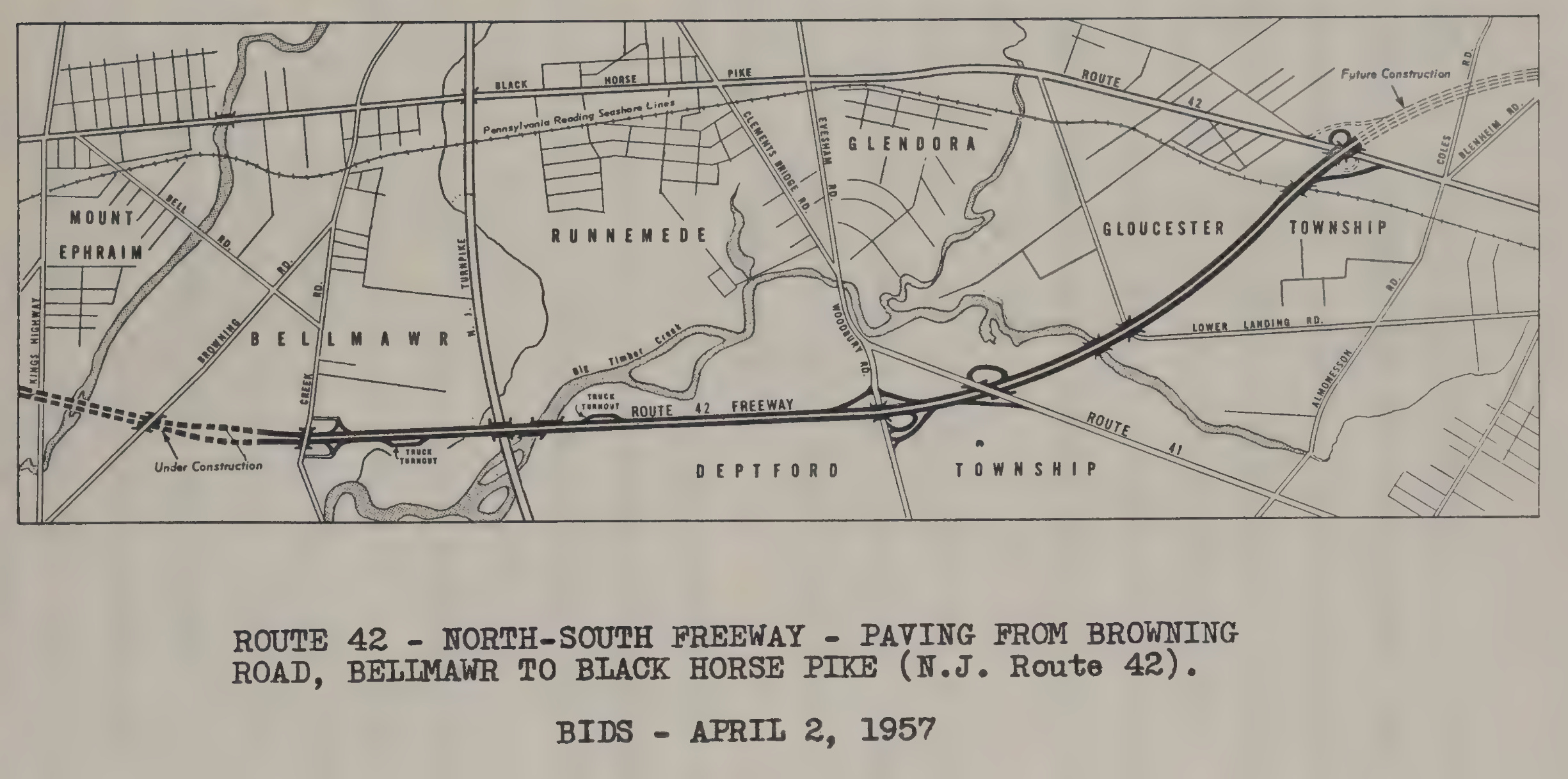
That said, the April 1957 Monthly Report shows the area of the interchange, but doesn't really suggest any existence of the then-future I-295. As the Browning Road overpass was constructed at this time, I also wonder if the awkward design of the interchange was part of a compromise so the Browning Road overpass didn’t need to be rebuilt.
There was a 1960 map from the Delaware River Port Authority which only shows a connection from I-76 EB to I-295 NB and from I-295 SB to I-76 WB, though this is likely because the interchange was still under construction at the time.
As the New Jersey Turnpike closely parallels I-295 for much of its length, it's highly likely that the vast majority of through traffic between Delaware and North Jersey/New York is using the New Jersey Turnpike instead of I-295. In theory, due to the existence of the New Jersey Turnpike, the only traffic that "should" be on I-295 is traveling between destinations along that highway (including Philadelphia) or is ultimately going to use the New Jersey Turnpike to reach Delaware or North Jersey/New York.
However, with employment centers continually moving away from city centers, highways like I-295 are now taking commuters between suburbs during rush hours, not just to and from major cities like Philadelphia.
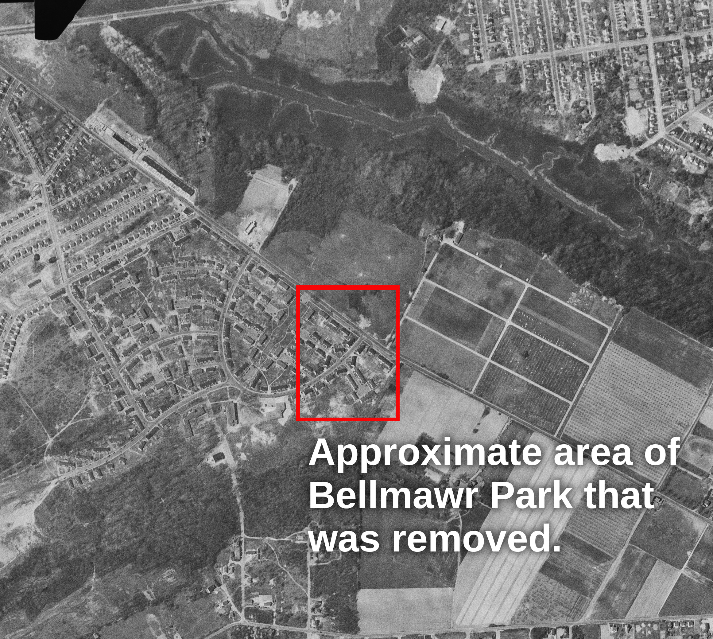
Bordering the I-295/I-76/NJ-42 interchange to the west, there is a neighborhood known as Bellmawr Park. Bellmawr Park was built in the early 1940s as a 500-unit development for shipyard workers who couldn't afford homes in the Philadelphia area. The entirety of the neighborhood has been owned by the Bellmawr Park Mutual Housing Corporation.
Bellmawr Park is an interesting neighborhood in terms of its configuration. According a 2015 court case, Bellmawr Park neither sells nor rents its dwellings. Instead, residents enter into a "Mutual Ownership Contract," where they pay "low monthly payments" for perpetual use of the home. Residents are allowed to return possession to Bellmawr Park, with the option to sell any improvements made during the contract period.
Due to the nature of Bellmawr Park, its sheer existence could have forced the awkward alignment of the continuous I-295.
Being constructed by the Federal government just a few years before the I-295/I-76/NJ-42 interchange, there was probably reluctance to remove this basically new development, which involved a massive investment from the Federal government.
The mutual ownership of Bellmawr Park likely meant there were extremely significant hurdles if either the State of New Jersey or the Federal government tried to remove the neighborhood or a large part of it, as they wouldn't be negotiating with individual homeowners. Instead, they'd be negotiating with a relatively large housing development, which has always been under mutual ownership.
Even still, part of Bellmawr Park was demolished for the NJ-42 freeway, as evidenced by a comparison of aerial images from 1951 and 1959. These show that there were several buildings removed on the eastern side of the neighborhood. Minutes from the State Highway Department in 1957 did mention "difficulty experienced in securing a Right of Way Agreement with the Bellmawr Park Mutual House [sic] Corporation." Thus, it is highly possible that Bellmawr Park avoided far greater demolition, which partially led to this compromised interchange design.
The I-295/I-76/NJ-42 interchange has long been a problem in the area. The New Jersey Department of Transportation reports the following average annual daily traffic (AADT) counts on the routes passing through the interchange:
Note: All traffic counts from 2012-2014.
According to the environmental impact statement (EIS) for the current reconstruction project, the interchange is "the busiest in the region" and has a crash rate that is "more than seven times the statewide average." NJDOT has identified issues with the interchange at least since 1985. Studies were performed from 1987 to 1999 to determine future major improvements.
This study ultimately led to 26 conceptual alternatives, which were reduced to 6 alternatives (5 "build" alternatives and the "no-build" alternative) after considering input from the community and regulators. These meetings lasted from 2001 to 2008, emphasizing the difficulty in coordinating such a complex project.
I will not describe each alternative in detail, as those can be found in the EIS. Click here for the official map of the selected alternative. However, the selected alternative can be described briefly as follows:
Links were active at the publication of this article on July 15, 2025.