The Evolution of Delaware's North-South Freeway
In Delaware, State Route 1 is the second-longest route in the
state, less than one mile shorter than US Route 13's mileage in
the state (102.6 miles vs. 103.3 miles). This designation first
came about in the 1970s, eventually replacing Delaware Route 14
south of Milford. As time went on, the highway overlapped (and
eventually replaced) US Route 113 from Milford to Dover and was
extended up what was once called the "US-13 Relief Route" from
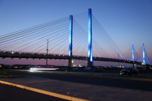
Dover to Christiana. Various scenes of Delaware Route 1 are
shown below, all photos are from my personal collection.


Left: Southbound approach to
William V. Roth, Jr. Chesapeake and Delaware Canal Bridge in the
Delaware City area.
Middle: Southbound view of the Milford Bypass near the Milford
Hospital.
Right: Indian River Inlet Bridge at Delaware Seashore State
Park.
The Early Days of the Milford Bypass
The Milford Bypass was planned as part of the original
dualization of Delaware Route 14 (today's DE-1), between Five
Points/Lewes and Milford, with three alignments under
consideration. The map below, from a 1957 engineering report
on the expansion of the road, shows the three alternatives
considered for the Milford Bypass.
 Three alternatives considered for the alignment of the Milford
Bypass in 1957. Source: Delaware State Highway
Department, Engineering Report, State Route 14: Five Points to
US Route 113, Sussex County, Delaware (1957). Reproduced
with permission from the Delaware Public Archives.
Three alternatives considered for the alignment of the Milford
Bypass in 1957. Source: Delaware State Highway
Department, Engineering Report, State Route 14: Five Points to
US Route 113, Sussex County, Delaware (1957). Reproduced
with permission from the Delaware Public Archives.
These alignments can be described as follows,
heading north/west from Road 207/Johnson Road:
- Line I (recommended) - Heading generally westerly to a
trumpet interchange with US-113 south of Seabury Avenue.
- Line II - Following today's alignment to the Rehoboth
Boulevard interchange (just north of the Milford Hospital),
then running west-southwesterly towards US-113 south of
Seabury Avenue.
- Line III - Today's alignment, though US-113 is the
preferred route at the Milford Bypass/US-113 interchange,
instead of the Milford Bypass.
More detailed
plans for the proposed Line I alignment can be found here,
from the same document. These images were
"stitched together" by me.
There was a short period when the section between today's
DE-1/US-113 split in the northern part of Milford and today's
DE-1/DE-1 Business/DE-30 interchange in the southern part of
Milford had no state route designation. Below are some excerpts
from DelDOT plans from 1967, showing how this undesignated route
was signed.


Left: Northbound signage approaching the southern portion of the
Milford Bypass (today, this would be at DE-1 and DE-1 Business).
Middle: Signage on DE-36 approaching the Milford Bypass.
Right: Southbound signage approaching the northern portion of
the Milford Bypass.
Source: DelDOT Historical Plans, Project ID 67-08-008.
The Planned US-301 Freeway
Believe it or not, the Milford Bypass was the first freeway-like
segment of today's Route 1 that was constructed, first appearing
on DelDOT's state highway maps in 1967 and opening in 1971. Prior
to that, the only seriously considered plans I know of related to
a long north-south freeway in Delaware were for an upgraded
US-301, connecting the Chesapeake Bay Bridge in Annapolis,
Maryland to the Delaware Memorial Bridge in New Castle. This road
would have only made it as far as Middletown, not serving anywhere
further south in Delaware.
However, these plans for the US-301 freeway were serious enough
to warrant construction of the current Summit Bridge and its
approaches, built in the late 1950s, to freeway standards.
According to the historical plans DelDOT has made available on the
state's public GIS database (FirstMap), the US-301 freeway was to
have ended at I-95 somewhere between DE-72 and Salem Church Road,
with a cloverleaf interchange at US-40 in the Glasgow Park area,
eventually reaching the Summit Bridge. In the Summit Bridge
area, there was a planned interchange at DE-71 on the north side
of the Chesapeake and Delaware Canal, as well as a planned
interchange with DE-896 on the south side of the canal.

Freeway-like approaches to the Summit Bridge, heading
northbound. Footage from my dashcam (September 2023).
Diversion: Proposed Highways in Delaware in the 1950s
Like many other states, Delaware had numerous highways proposed
in the 1950s. This will mainly review the Delaware State
Highway Department's (DelDOT's predecessor) 1959 document Controlled
Access Highways: A Report by the Delaware State Highway
Department on Future Highway Needs. I read this
document at the Delaware Public Archives in July 2023.
 This map shows the state's long term plans for a
highway network, as of 1959. Some of these plans are
described in detail below. Source: Controlled Access
Highways: A Report by the Delaware State Highway Department on
Future Highway Needs (1959). Reproduced with permission
from the Delaware Public Archives.
This map shows the state's long term plans for a
highway network, as of 1959. Some of these plans are
described in detail below. Source: Controlled Access
Highways: A Report by the Delaware State Highway Department on
Future Highway Needs (1959). Reproduced with permission
from the Delaware Public Archives.
The US-301 Expressway
Numerous sources described a US-301 freeway in the Middletown
area. The earliest document was Connecting Highways
Between the Delaware Memorial Bridge and the Maryland Line Near
Warwick, dating to December 1950. This described many
routes between New Castle and Middletown, including those that
would have followed the Saint Georges Bridge (today's US-13
bridge, then the main bridge across the canal) and those that
would have followed a new Summit Bridge (today's Summit
Bridge). Some maps from this document are linked below,
reproduced with permission from the Delaware Public Archives:
In the Delaware State Highway Department's Controlled Access
Highways, the plans for a US-301 expressway were similar to
those described above, running from I-95 near Newark down to the
Summit Bridge. The plans shown in the FirstMap database have
a trumpet interchange (commonly seen on the Pennsylvania Turnpike)
between I-95 and US-301, while 1959 plans for I-95, prepared by
the firm Howard, Needles, Tammen, and Bergendoff show a
directional "Y" interchange at the proposed US-301 expressway with
left exits and entrances on I-95 southbound (commonly seen in
Connecticut).
Frederica and West Dover Bypass
The Controlled Access Highways document recommended a new
alignment for US-113 between Frederica and Dover, plus a West
Dover Bypass. An engineering report was prepared by the firm
De Leuw, Cather, and Brill in 1959, which described this proposed
bypass in detail. The Delaware Public Archives gave me
permission to reproduce these maps, showing how the West Dover
Bypass would have been aligned.

This map shows the alignment considered for the West Dover
Bypass, which was never constructed. Source: State of
Delaware Highway Department, Supplement to Engineering Report,
Proposed Divided Highway from Frederica to Dover, Kent County
(1959). Reproduced with permission from the Delaware
Public Archives.
The West Dover Bypass had proposed interchanges with US-13 (north
of DE-10) in Camden, DE-8 (east of Kenton Road) in Dover,
terminating at US-13 (south of Denneys Road) in North Dover.
The US-13 and DE-8 interchanges were both proposed near where
Redners supermarkets are today. The northern terminus is
near where the Delaware Technical and Community College Terry
Campus is today, incidentally also near a Redners. Detailed
plans of the section from Camden to North Dover are shown here,
from the same document ("stitched together" by me).
US-13 Relief Route
Controlled Access Highways expressed the need for a US-13
relief route, not just within Dover, but also between Dover and
Middletown. It described a route to the west of US-13,
serving as a "connection between Route 71 at Middletown, passing
west of Smyrna, and connected with the West Dover Bypass."
This document recommended that the relief route be constructed as
a two-lane highway with eventual expansion to four lanes.
More detail on eventual plans for the US-13 relief route are
described throughout this article.
I-95 Relief Route
It wasn't just US-13 that Delaware was looking to relieve.
Controlled Access Highways showed considerations for a
route "projecting Route 71 to the north of and parallel to
Kirkwood Highway," to relieve I-95. The report went on to
say that the "feasibility of this particular route [...] will be
greatly affected by the location of suburban development."
Other Proposals
Controlled Access Highways presented a few more highways
throughout Delware, none of which were ever constructed:
- Route 202 or Route 41 Relief Route: No further
detail other than "another connection to the Pennsylvania
Highway System would be necessary."
- Frederica/Milford to Bay Bridge: Extension of
the South Milford Bypass down to the Maryland line east of
Denton (Burrsville area). This would provide a connection
to Route 404 and the Chesapeake Bay Bridge. This would
eventually provide a connection between Milford and Frederica,
presumably to connect with the Frederica Bypass.
- Southern US-13 Relief Route: Described as
running from Dover to Greenwood, "considerably to the west of
US-13, which now bypasses all present communities on the eastern
side."
- Milford to Georgetown: Suggested improving
US-113 from Milford to Georgetown with a four-lane route,
including frontage roads to serve existing development.
- Central Sussex County East-West Route: Initially
proposed as a "new highway between Georgetown and the beaches,"
with the eastern terminus proposed "immediately north of the
Indian River." After that statement, though, is a very
interesting comment. "...or further north, depending on
developments related to a Delaware Bay Crossing to Cape
May." This makes one wonder if there were plans for a
Delaware Bay Bridge at the time. Not as interesting, but
later in the document, it is suggested that this highway
continue west to Seaford and the Maryland state line.
Early Plans for US-13 Relief: The Westerly Route
I described the US-301 freeway here because, apparently, the
earliest public mention of a long-distance north-south freeway
proposal in Delaware was in a 1972 article in Wilmington's Morning
News. The map shown on this article implies that the planned
freeway likely would have followed the proposed US-301 freeway
from I-95 to Middletown, taking its own route south to Camden (the
next town south of Dover). Interestingly, the 1972 proposed
route was entirely to the west of US-13, by several miles in some
cases, contrasting with today's DE-1 which zig-zags over and under
US-13 multiple times. The 1972 article's map is shown below.

Proposal for a north-south freeway between Newark and Dover,
from a 1972 Wilmington Morning News article.
Source: Delaware Turnpike Scrapbooks (Delaware Public Archives).
That being said, we know that the westerly route of what would
become Delaware Route 1 never came to fruition. There was never a
freeway built across the Summit Bridge, though Delaware Route 896
did receive some major upgrades between I-95 and the bridge in the
1990s to handle increasing traffic. In Dover, the West Dover
Bypass, one of the predecessors of the north-south freeway, was
highly controversial, especially among farmers. Today's DE-1 runs
east of US-13 at all points south of Smyrna, including Dover.
Additional articles from Dover's Delaware State News
(1975), Wilmington's Morning News (1976), and Wilmington's
News Journal (1978) describe early proposals for the road.
In 1975, Governor Sherman W. Tribbitt announced his opposition to
the construction of the road. In 1976, outgoing Secretary of
DelDOT Clifford Hall proposed making the north-south freeway part
of the Interstate highway system, allowing for 90% Federal funding
of the project, with Delaware Turnpike (I-95) surplus tolls paying
the remaining 10%. In the same article, incoming Governor Pierre
S. DuPont IV announced that he opposed the West Dover Bypass,
echoing concerns from the agricultural community. That said,
multiple 1978 articles discussed the same Governor DuPont working
with a committee to "review the possibilities" for the road,
presumably on other alignments.
Shifting to the East: Today's Route
A 1985 article in the Delaware State News suggested that
the plans for Route 1 were narrowed down to a "near-west" and
"near-east" alignment, presumably referring to its alignment
relative to US-13. The 1987 Draft Environmental Impact Statement
(EIS) for the US-13 Relief Route, today's Route 1, covered the
distance from DE-7 and DE-71 near Red Lion to US-113 at the Dover
Air Force Base (AFB) or Frederica, depending on the selected
alternative.
The 1987 EIS split the road into three segments: Odessa (Red Lion
to Blackbird), Smyrna (Blackbird to Cheswold), and Dover (Cheswold
to Dover AFB or Frederica). The Odessa and Smyrna segments had
Railroad, Near East/Near West, and Upgrade alternatives. The Dover
segment had Western Alignments and Eastern Alignments as
alternatives, as well as an Upgrade alternative. A map of the
alternatives is shown below.

Proposed alternatives for the US-13 Relief Route, between Red
Lion and central Kent County. Source: US-13 Relief Route
Draft Environmental Impact Statement (1987).South of Middletown, the Railroad alternatives in the Odessa and
Smyrna segments were similar to what was shown in the 1972
Wilmington Morning News article. They approximately follow
the route of the Delmarva Central Railroad, which runs a fairly
straight path down the state, until it splits at Harrington.
Ultimately, the alternatives selected were Near East, Near
West/Near East, and the Eastern Alignments, respectively.
The illustrations below are from the 1987 EIS for the Relief
Route, showing the potential visual impacts of the highway,
particularly from the upgrade alternative. Personally, I cannot
imagine how a direct upgrade of US-13 would have looked in Smyrna
or Dover, with the highway passing directly through those towns.
Left: Illustration of Smyrna with the
"upgrade" alternative.
Middle: Illustration of Cheswold with the "near west"
alternative.
Right: Illustration of Dover with the "upgrade"
alternative.
Source: US-13 Relief Route Draft Environmental Impact
Statement (1987).
Interchanges Left Incomplete or Unconstructed
There is one interchange on the DE-1 freeway that remains
incomplete. In Dover, the planned ramp from southbound Bay Road to
northbound DE-1 was never constructed, though there was concrete
laid on DE-1 for the entrance ramp. However, plans from 1989
suggest that this was a "future ramp," though I've never heard of
any plans to actually construct it. Currently, this movement is
served by making a u-turn from southbound Bay Road at the Lafferty
Lane stoplight, then taking the northbound Bay Road to northbound
DE-1 ramp.

Aerial image of the area of the "future ramp" linking
southbound Bay Road to northbound DE-1. Source: DNREC
Aerial Imagery (2022).

Right-of-way plans for DE-1 showing the aforementioned "future
ramp." Source: DelDOT Historical Plans, Project ID
89-11-101.In the Blackbird/Townsend area, there were plans for an
interchange with US-13 and DE-71. This was even shown on maps made
available to the general public, like the ADC New Castle
County, Delaware Street Map Book from 1997. However, it
appears that only the original right-of-way acquisitions showed
plans for this interchange. The actual construction plans do
not show an interchange here, which would explain why there is no
real evidence of the proposed interchange's path today.

1983 right-of-way acquisition plans for DE-1, between Smyrna
Rest Area and the Blackbird area. Note the proposed
interchange with US-13 near DE-71. Source: DelDOT
Historical Plans, Project ID 83-11-002e.

1991 construction plans for DE-1, between Smyrna Rest Area and
the Blackbird area. Note the lack of interchange with
US-13 near DE-71. Source: DelDOT Historical Plans, Project ID
91-11-014.
Beyond US-13 Relief: Removing At-Grade Intersections from Dover
to Lewes
The US-13 Relief Route was only intended to run as far south as
Dover Air Force Base. A strict definition would place it a
bit further north at Exit 97, the Puncheon Run Connector, a short
freeway spur that runs to US-13 at the southernmost part of Dover,
around the Rodney Village neighborhood. Over the years,
though, DelDOT has upgraded numerous at-grade intersections along
Route 1 to grade-separated interchanges. These are designed
to improve traffic flow and safety along the route, especially
during the busy summer months, as the road takes travelers to the
Delaware Beaches and Ocean City, Maryland. Upgrades were
made at the following locations, arranged north to south:
- Delaware Route 9 (Kitts Hummock)
- Bowers Beach Road (Magnolia)
- Delaware Route 12 (North Frederica)
- Milford Neck Road (South Frederica)
- Thompsonville Road (North Milford)
- Delaware Route 14 (Downtown Milford)
- Delaware Route 30 (South Milford)

The DE-14 overpass at DE-1 on May 18, 2019, its opening day,
eliminating a dangerous crossover for traffic going to and from
Downtown Milford, the largest city in the southern half of the
state. Photo from my personal collection.
As of this writing (January 2024), DelDOT is constructing a grade
separated interchange at DE-16, east of Milton. This would
remove the last stoplight between I-95 and the Five Points
intersection outside of Lewes. After this, they plan to
construct a grade-separations at two intersections between Lewes
and Milton: Minos Conaway Road (planned construction beginning in
Summer 2024) and Cave Neck Road (planned construction beginning in
Spring 2026).
DelDOT has published long-term plans for Route 1 on their
website, under the Corridor Capacity Preservation Program.
This includes the following plans for DE-1, according to the
Proposed 2022 SR1 Plan Update Maps (retrieved on January 2,
2024). I am presenting these summarized plans in
north-to-south order. Note that the long-term plans appear
to include frontage roads for considerable distances where there
are multiple direct accesses to DE-1 today.
Area
|
Intersection
|
Plan
|
Magnolia
|
Barkers Landing
Road
|
Improve
existing grade separation
|
Magnolia
|
Bowers Beach
Road
|
Already
grade separated
|
Frederica
|
Barratts Chapel
Road (SB)
Skeeter Neck Road (NB)
|
Add new
overpass
|
Frederica
|
DE-12
|
Already
grade separated
|
Frederica
|
Milford Neck
Road
|
Already
grade separated
|
North Milford
|
Old Cemetery
Road (SB)
|
Right-in/right-out
|
North Milford
|
Cicada Lane
(SB)
|
Right-in/right-out
|
North Milford
|
Big Stone Beach
Road (NB)
|
Right-in/right-out
|
North Milford
|
Tub Mill Pond
Road (SB)
|
Right-in/right-out
|
North
Milford
|
US-113
|
Already
grade separated
|
North
Milford
|
DE-14
|
Already
grade separated
|
South
Milford
|
DE-36
|
Already
grade separated
|
South
Milford
|
DE-1
Business
|
Already
grade separated
|
South
Milford
|
DE-30
|
Already
grade separated
|
Lincoln
|
Johnson Road
(SB)
|
Right-in/right-out
|
Lincoln
|
Sharps Road
(NB)
|
Right-in/right-out
|
Argos Corner
|
Brick Granary
Road (SB)
Argos Corner Road (NB)
|
Right-in/right-out
|
Argos Corner
|
Slaughter Beach
Road
Pine Haven Road
|
Full diamond
interchage
|
Argos Corner
|
Argos Corner
Road (NB)
|
Right-in/right-out
|
Argos Corner
|
Daniels Road
(SB)
|
Right-in/right-out
|
Argos Corner
|
Slaughter Neck
Road (SB)
Sugar Hill Road (NB)
|
Right-in/right-out
|
North Milton
|
Clifton Road
(SB)
Truitt Road (NB)
|
Right-in/right-out
|
North Milton
|
Sylvan Acres
Road (SB)
Prime Hook Road (NB)
|
Right-in/right-out
|
North Milton
|
DE-5
Deep Branch Road
|
New connection
with overpass, right-in/right-out
|
North Milton
|
DE-16
|
Grade
separation under construction
|
South Milton
|
Steamboat
Landing Road
Hudson Road
|
New connection
with overpass, right-in/right-out
|
South Milton
|
Eagle Crest
Road (SB)
Oyster Rocks Road (NB)
|
Right-in/right-out
|
South Milton
|
Cave Neck Road
|
Grade
separation planned for construction 2026-2028
|
Lewes
|
Minos Conaway
Road
Nassau Road
|
Grade
separation planned for construction 2024-2027
|
← Back to
Road Projects
Sources Consulted
Links were active at the time of publication of this article on
January 2, 2024.
- US-13
Relief Route Draft Environmental Impact Statement (Route 7 to
US-113)
- Delaware
Department of Transportation (DelDOT) Historical
Transportation Plans
- Delaware
Department of Transportation (DelDOT) Historical State Highway
Maps
- Delaware
Department of Transportation (DelDOT) Corridor Capacity
Preservation Program
- Delaware
Department of Transportation (DelDOT) Projects Portal
- Delaware
Department of Natural Resources and Environmental Control
(DNREC) Aerial Imagery
- Delaware
Turnpike Scrapbooks (Delaware Public Archives)
- Connecting Highways Between the Delaware Memorial Bridge
and the Maryland Line Near Warwick: A Report to the State of
Delaware Highway Department, prepared by Knappen Tippetts
Abbett Engineering Company, New York, December 1950 (read at the
Delaware Public Archives in Dover)
- Controlled Access Highways: A Report by the Delaware State
Highway Department on Future Highway Needs, May 1959 (read
at the Delaware Public Archives in Dover)
- Delaware Interstate Highway Route FAI-1, Delaware State
Highway Department, prepared by Howard, Needles, Tammen,
and Bergendoff Consulting Engineers, 1959 (read at the Delaware
Public Archives in Dover)
- Delaware State Highway Department, Engineering Report,
State Route 14: Five Points to US Route 113, Sussex County,
Delaware, prepared by Rummel, Klepper, and Kahl Consulting
Engineers, Baltimore, 1957 (read at the Delaware Public Archives
in Dover)
- State of Delaware Highway Department, Supplement to
Engineering Report, Proposed Divided Highway from Frederica to
Dover, Kent County, prepared by De Leuw, Cather, and Brill
Engineers - Architects, New York, 1959 (read at the Delaware
Public Archives in Dover)
- ADC New Castle County, Delaware Street Map Book, 1997


