Approaches to the I-70/US-250 interchange in June 2023. Footage from my dashcam.
In March 2022, I was on a work trip to Wheeling, West Virginia. On that trip, I happened to take part of the US-250/WV-2 expressway to Benwood, to see the long-abandoned, yet still standing Bellaire Interstate Bridge. The constructed portion of this expressway is interesting on its own, but there are some hints at a cancelled or proposed highway at the I-70 interchange. After that trip, I happened to meet my girlfriend, who is from Wheeling, so I've taken more of an interest in the area. Wheeling is one of the most important cities in West Virginia, having served as:
It has consistently remained one of the largest cities in the state, currently the fifth largest. Of West Virginia's cities, it is the closest to any major city, sitting just 60 miles (70 minutes) from Pittsburgh, Pennsylvania. The only other locations that even compare are Morgantown (76 miles, 80 minutes to Pittsburgh) and Martinsburg (78 miles, 90 minutes to Washington, DC).
As a result, Wheeling had a fairly extensive highway network
planned in the 1960s. Personally, I think the aforementioned WV-2
North Wheeling Expressway was the most interesting piece of this
network, but there are some honorable mentions, including the
I-470/US-250/WV-2 interchange in South Wheeling and the story of
the Bellaire Interstate Bridge between Benwood, West Virginia and
Bellaire, Ohio.
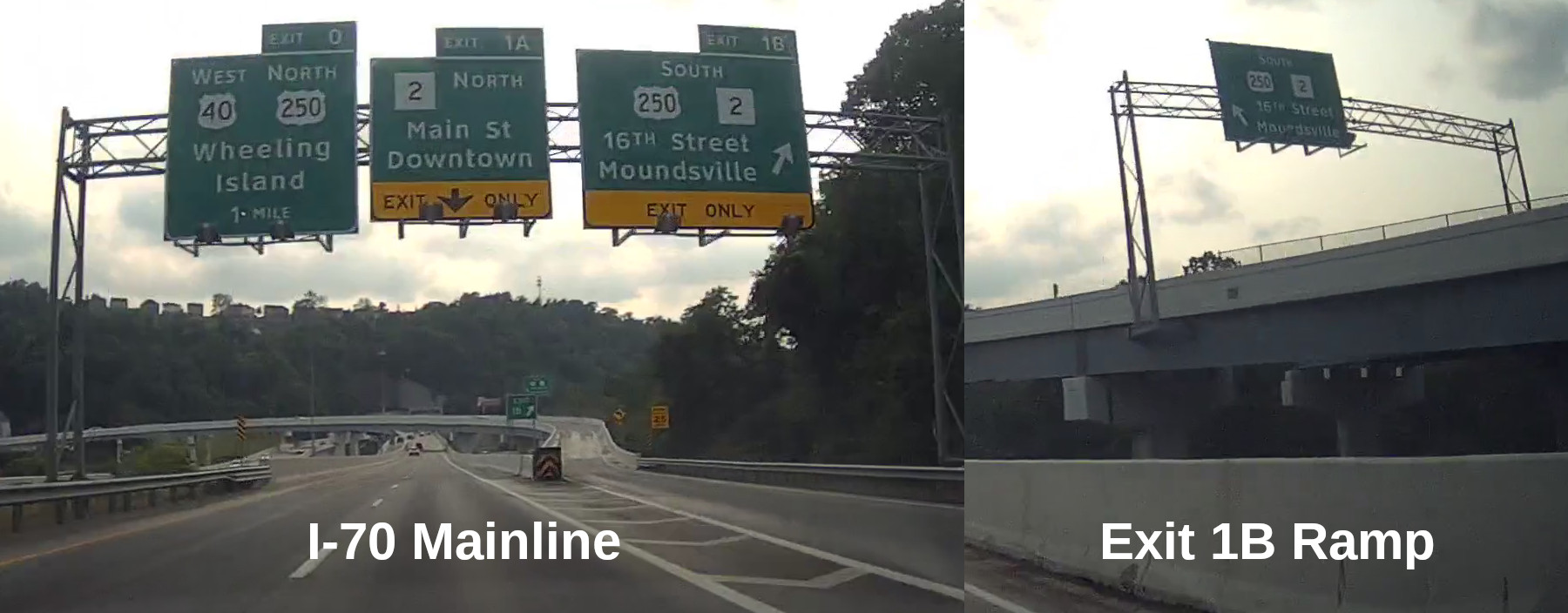
From a driver's perspective, on I-70 WB approaching Exit 1B (US-250 SB), the sign setup is unusual. The signs aimed at I-70 traffic are normal, but then the off-ramp to US-250 SB features an additional sign gantry, informing drivers they must exit left to continue onto US-250 SB. However, there's no option to go any other direction.
Approaches to the I-70/US-250 interchange in June 2023.
Footage from my dashcam.
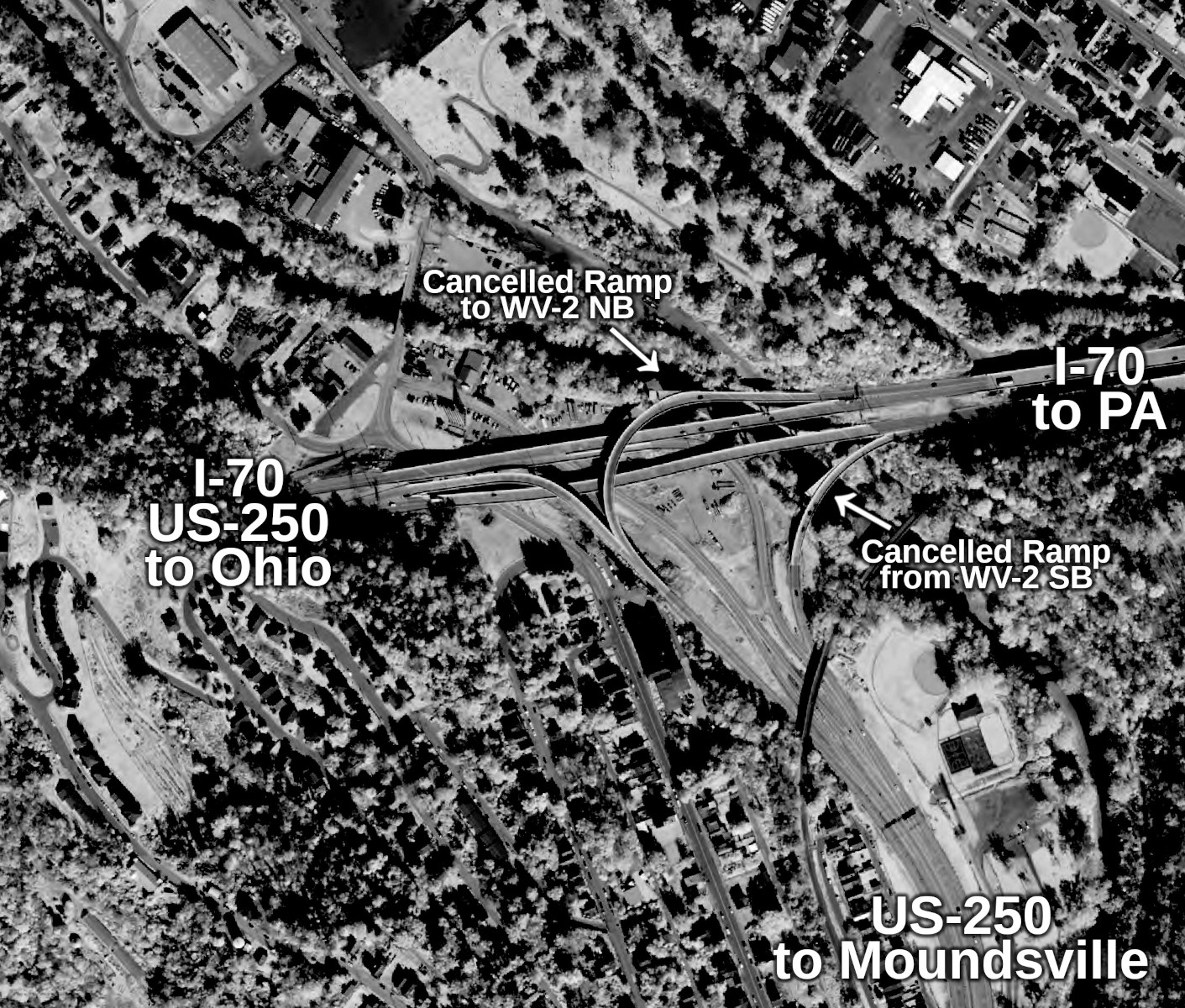
Looking at an aerial image, it becomes clear that the I-70/US-250 interchange was constructed with a highway to the north in mind, as the stub ramps become apparent. I tried to do some research on this road, but there’s limited information out there.
I did learn about a group called the Route 2/I-68 Authority, which was established by the West Virginia Legislature in 1997. Their goal is to extend I-68 its current western terminus at I-79 between Morgantown and Fairmont out to WV-2, presumably somewhere near Parkersburg. They'd also like to expand the existing WV-2 from Parkersburg to Chester into a four-lane highway.
Given that the goals for this group seem very ambitious and lofty, I don't think the Route 2/I-68 Authority has anything to do with these stub ramps. Additionally, further research suggests that the I-70/US-250 interchange long predates the existence of the Route 2/I-68 Authority. An email to the West Virginia Department of Transportation (WVDOT) and the Belomar Regional Council, the metropolitan planning organization for the Wheeling metropolitan area, confirmed this. According to Rakesh Sharma, Transportation Director with the Belomar Regional Council,
"Your observation is correct. A Roadway stub at this interchange was built with the intention of connecting to a future bypass around center Wheeling. This bypass along with the northern parkway (another alignment with the same purpose) remained as unfunded projects in the earlier long range plans for the region. They have not been included in the fiscally constrained pans for over a decade."
Almost a year after this email, I found a public website from WVDOT that hosted their historical highway plans and engineering documents. After finding similar public databases from Delaware and Vermont, I knew that these databases sometimes have plans from projects that have long been cancelled (e.g., Delaware's original US-301 expressway, Vermont’s Burlington Beltline).
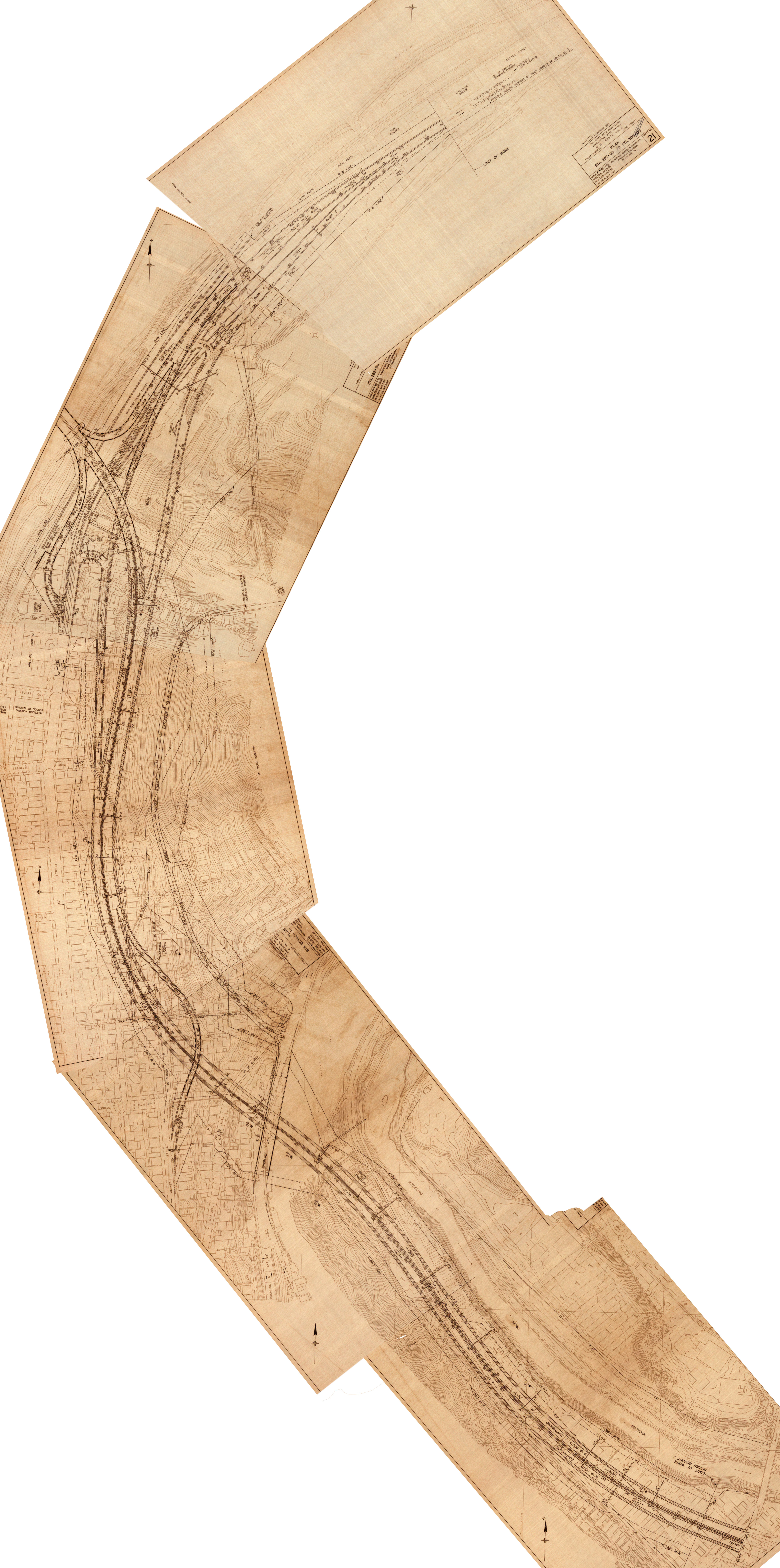
Thankfully, the WVDOT database has these plans! These were plans for WV-2 from "Interchange 9 to Interchange 10," dating to 1969. The document has left out the details of the I-70 interchange, but it shows the intended path of the WV-2 expressway and its impact on East Wheeling and North Wheeling, from structures to city streets. More detailed engineering plans can be shown here, provided by WVDOT, stitched together by me.
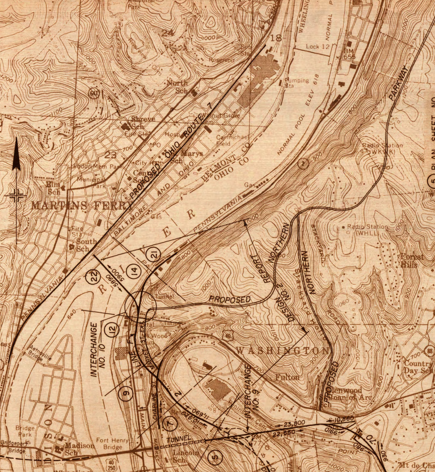
The expressway was to have run between I-70 and WV-2 at approximately the northern tip of Wheeling Island (as a reference point). Several streets in North Wheeling would have been closed or relocated in the expressway's path, including US-40/National Road, a major artery in Wheeling and an important local alternate to I-70. The expressway featured an interesting interchange with WV-2 at its northern end, which leads to another interesting feature of these plans.
Not only was an expressway proposed to North Wheeling, but the roadway was also meant to continue across the Ohio River to Martins Ferry, Ohio (presumably to OH-7, a major highway running along the river). This would have provided a fourth crossing of the Ohio River within the City of Wheeling today (existing crossings being the I-70/US-40/US-250 Fort Henry Bridge, I-470 Vietnam Veterans Memorial Bridge, and the Wheeling Suspension Bridge – closed to vehicles).
There's limited information about this bridge, especially since only plans on the West Virginia side can be found, there is nothing to be found on the Ohio side of the bridge. These plans do show that the bridge would have featured four lanes, with three possible approaches to the WV-2 expressway and the existing WV-2. In essence, it could have been a grade separated interchange or a simple 4-way intersection. This also would have affected the northern terminus of the WV-2 expressway, accordingly.
Another observation from these plans is that there was apparently no provision for a ramp from I-70 EB to WV-2 NB, nor was there a ramp from WV-2 SB to I-70 WB. There could be several reasons for this, but I'd imagine the easiest answer is just space constraints. There would be no reasonable way to create a safe entrance ramp from WV-2 SB to the approach into the Wheeling Tunnel on I-70 WB. A ramp from I-70 EB to WV-2 NB may have been feasible, but it could have been considered unnecessary as traffic would not save any time over taking the existing WV-2, which already has a ramp from I-70 EB between the Fort Henry Bridge and the Wheeling Tunnel.
As an aside, I don't have any further details on the Northern
Parkway that was mentioned by Sharma. All I know is that part of
it was built, between WV-2 and Mount Wood Road in North Wheeling.
Examination of the WV-2 plans suggest that it would have run just
to the east of WV-2 at least up to Warwood.
South Wheeling's interchange between I-470 and US-250/WV-2 is of
a somewhat rare variety, described in the road enthusiast
community as the "volleyball
interchange." The only other similar interchange I know of
in any surrounding states is the interchange between I-476 and
US-1 in Media, Pennsylvania, outside of Philadelphia. An
aerial image of the interchange in Wheeling is shown below.
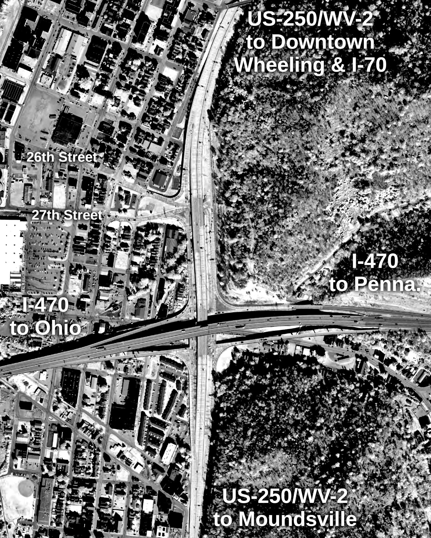
The interchange functions as two perpendicular diamond interchanges, with an intermediate square of service roads to connect the two roads, using stoplights. The interchange also provides an intermediate at-grade connection between 26th and 27th Streets in South Wheeling, via the ramps to and from US-250/WV-2 on the north end of the interchange.
That said, some alternatives were considered for the interchange. According to the Draft EIS for these sections of I-470 and US-250/WV-2, there were 10 schemes proposed, which are shown below.
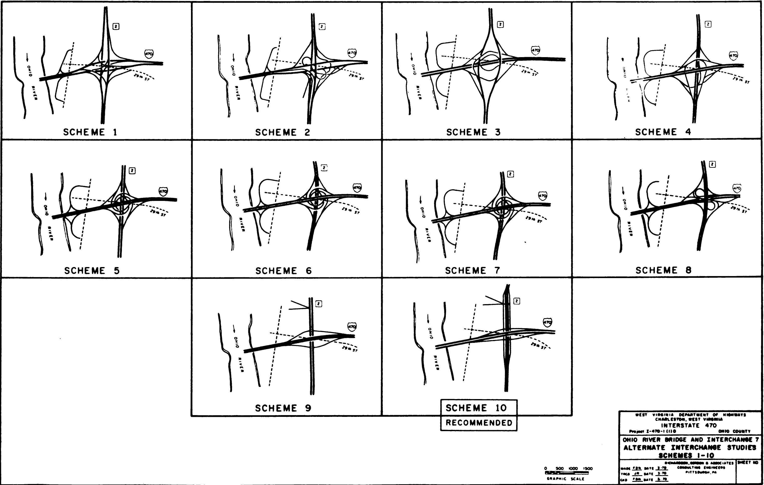
The most aesthetically interesting of these interchanges are Schemes 5, 6, and 7, of a circle/turbine design, reminiscent of the "circle stack" between I-787 and US-9/US-20 in Albany, New York. Scheme 9 is also interesting, as it suggests a simple diamond interchange with US-250/WV-2, requiring all traffic on that expressway to approach an at-grade interchange, similar to the interchange between I-79 and the US-50 expressway in Clarksburg.
Ultimately, the "volleyball" interchange was selected due to its
economical advantages, both directly (less expensive to construct)
and indirectly (fewer land acquisitions required). The fewer land
acquisitions also meant that the impact on the surrounding area
was somewhat less significant.
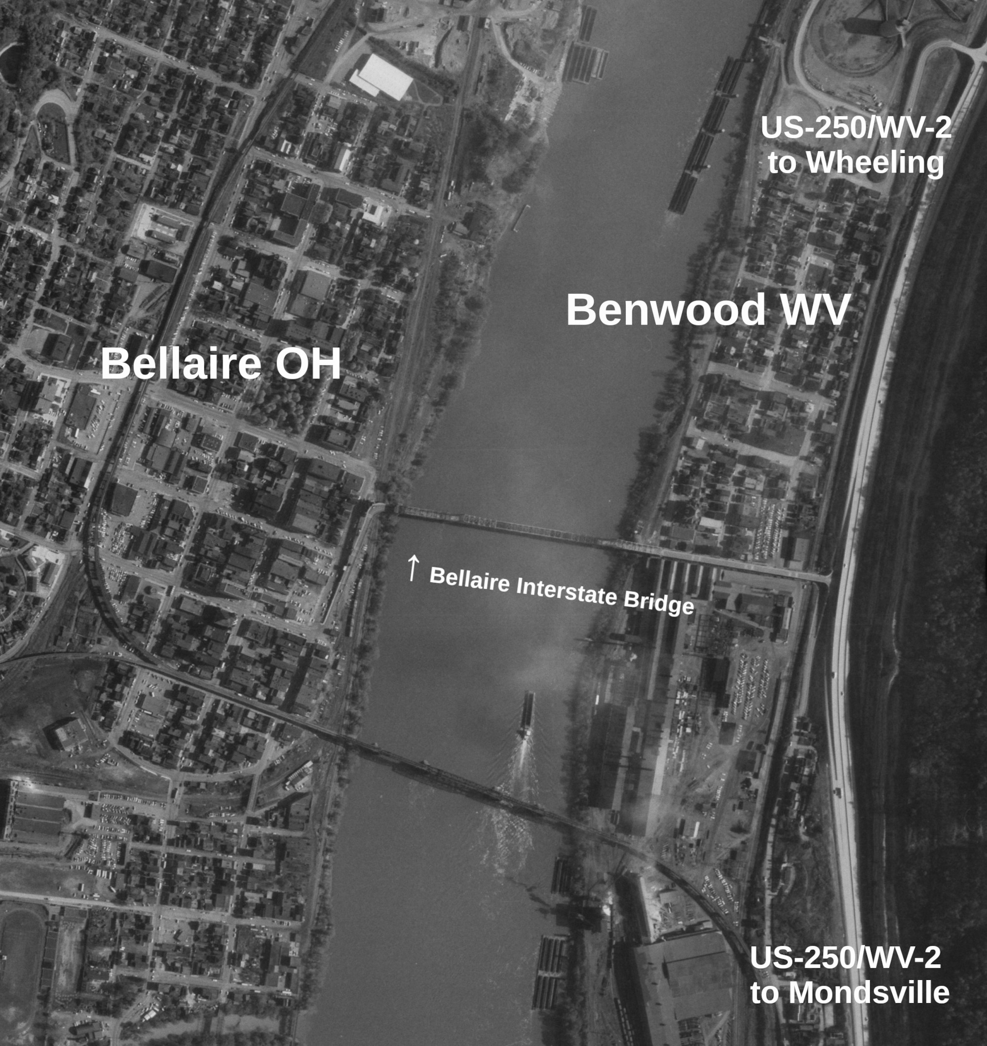
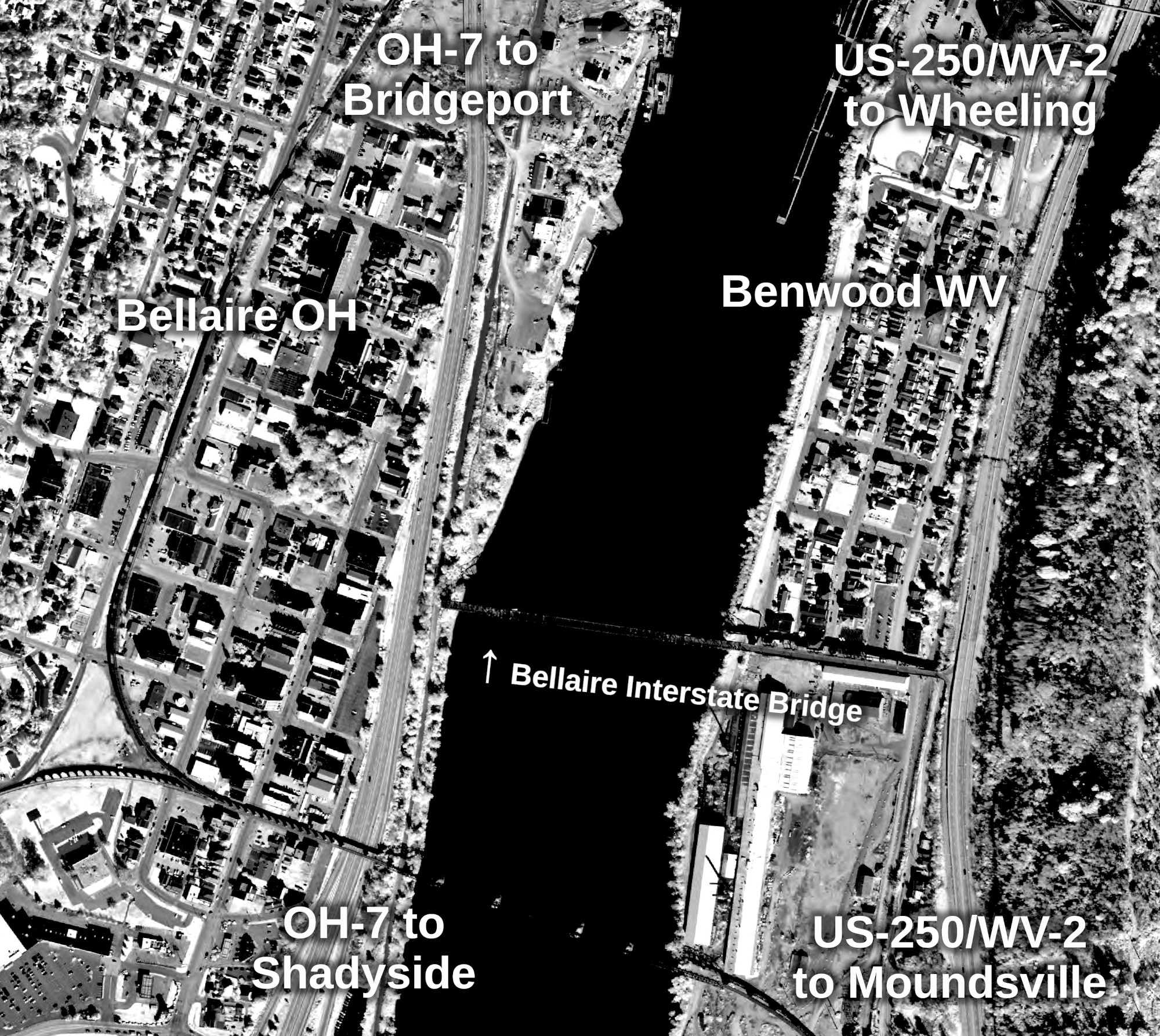
I think a very unfortunate transportation story in the Wheeling area is that of its bridges. From the Fort Steuben Bridge in Steubenville, Ohio to the numerous demolished truss bridges over the Ohio River, one bridge still stands as a constant example of the neglect given to some of the most beautiful bridges in this country.
There is plenty to read about the Bellaire Interstate Bridge from Historic Bridges and Bridges and Tunnels with Sherman Cahal. In short, it opened in 1926 as a toll bridge and was closed in 1991 when the Ohio Department of Transportation (ODOT) was upgrading OH-7 and cut off access to the bridge. Apparently, the bridge was sold to a new owner who had interest in operating it, sometime during the OH-7 upgrade process. However, with no access to the bridge on the Ohio side, the bridge stood by, remaining unused. By 2010, pressures mounted for demolition of the bridge and demolition and scrap materials rights have been battled in court ever since. The following is an examination of plans surrounding the bridge around the time of the OH-7 upgrades through Bellaire.
On my trip to Wheeling in March 2022, I was able to see the bridge in person, though there was quite a bit of sun glare in my photos. I was viewing the bridge from Benwood, West Virginia.
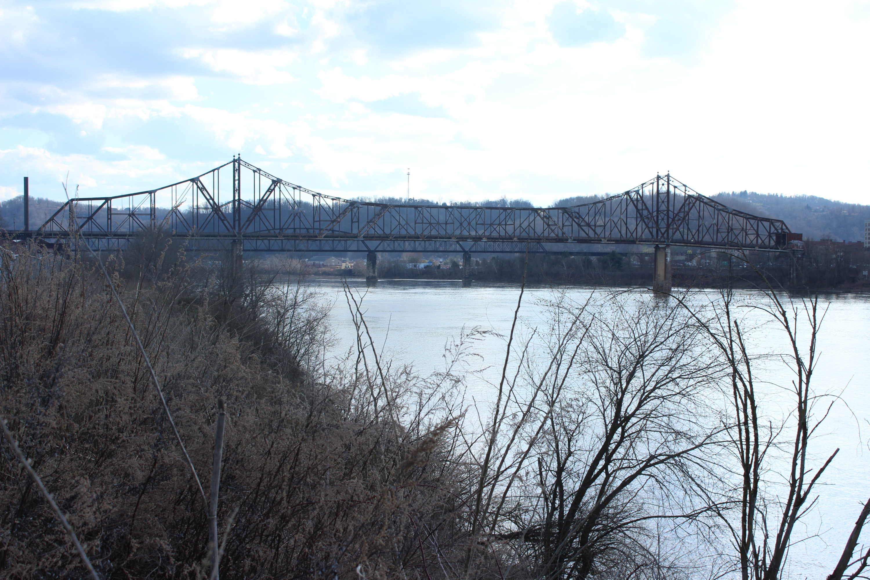
While the bridge is very derelict, it is clear that it was a beautiful bridge in its prime. This can be said about many other bridges that have lost to time, neglect, and "progress," including the Waldo-Hancock Bridge in Maine, the Fort Steuben Bridge in Ohio, and the I-74 Iowa-Illinois Bridge, among many others. Many of the replacement bridges are of the cable-stayed variety. I used to really like cable-stayed bridges, but now they are just starting to all look the same.
Anyway, the reason I mention this bridge in this article is because it is still standing. West Virginia did incorporate ramps to the bridge in their 1964 design of the US-250/WV-2 expressway. The ramps still exist today, though they’ve been closed to the public since at least 1993.
On the Ohio side, according to the environmental impact statement for the section of OH-7 through Bellaire, which was constructed in 1991, there were plans to construct a new approach to the Bellaire Interstate Bridge, but they never came to fruition. Of course, this led to the bridge’s ultimate demise.
I cannot find much on why the approaches to the bridge were never constructed. Outside of the small piece of the planned approaches that I can see, there is no mention of the Interstate Bridge in the environmental impact statement. I did some research on parcel records in Belmont County, which did at least give some hint as to what the property's intended use was. From this, I found the deed where ODOT paid the Interstate Bridge Company of Ohio, owner of the bridge, $2.1 million for the parcel where the original approaches to the bridge sat. This parcel is now entirely covered by the present day OH-7 expressway.
There are some parcels to the southwest of the bridge, abutting OH-7, which are now parking lots. These parcels were presumably transferred to the State of Ohio in 1990 or 1991, based on surrounding parcels also owned by the State. It seems that these parcels would have been used for a new approach to the Bellaire Bridge. In 1994, they were subsequently transferred to the City of Bellaire. As stated in the deed for Belmont County parcels 29-03627.000 and 29-01842.001 (emphasis added, note that state parcel numbers do not correspond with county parcel numbers):
"Whereas, the State of Ohio (Ohio Department of Transportation) has determined that a portion of State Parcel No. 132-EL, and State Parcel Nos. 374-EL (Combined) and 382-EL (Combined) are no longer needed for highway purposes, and can be transferred to the City of Bellaire, Ohio, without affecting the integrity of said highway system."
The combined transfer of land to the City of Bellaire and the statement that the lands "are no longer needed for highway purposes" imply that, by 1994, ODOT had no interest in constructing an approach to the Interstate Bridge. This is apparently confirmed in a 2008 lawsuit between the owners of the bridge at the time and ODOT, where ODOT went as far as denying "having had any plans to rebuild the ramp," despite the following evidence to the contrary!
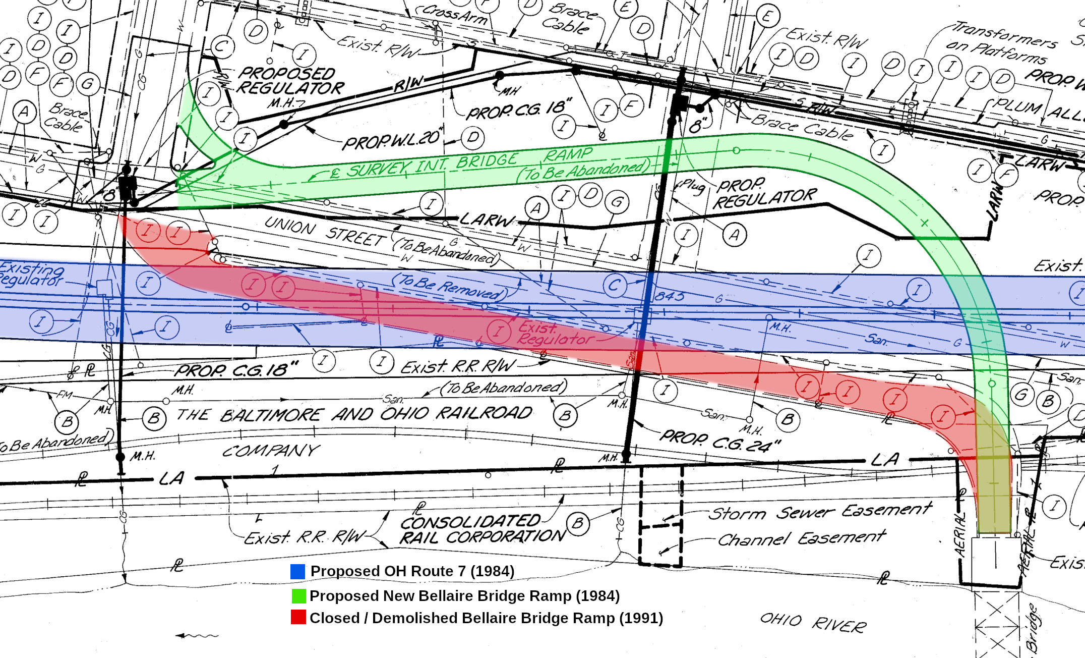
1984 right of way documents from ODOT, available to the public on
their OhRow Viewer website, show detailed engineering drawings for
their proposed replacement of the Interstate Bridge ramp. This
ramp would not directly connect with the relocated OH-7, it seems,
but it would have connected to the Bellaire street network at 32nd
Street and Union Street, using today's city-owned parcels, which
are currently nothing more than parking lots.
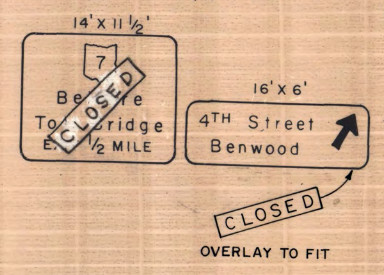
An excerpt from the 1984 right of way documents for OH-7 in Bellaire is shown below, with some annotations to help improve legibility. The "to be abandoned" remark on the then-proposed Bellaire Interstate Bridge ramp is in reference to the section of 33rd Street which was closed as part of the project. It has nothing to do with the bridge.
Links were active as of publication of this article on July 18,
2024.